La Niña cycle ended last week, which might help bring some relief this weekend
The town of Westcliffe was bustling this last weekend as temperatures reached summer-like conditions on Saturday. However, the high of 78 degrees set on April 12 was anything but normal and broke a 130-year record set in 1895 of 74 degrees. While April warmups have not been unusual the past four years, last weekend’s high was coupled with strong winds that decimated the critical snowpack in the Sangre de Cristo Mountains.
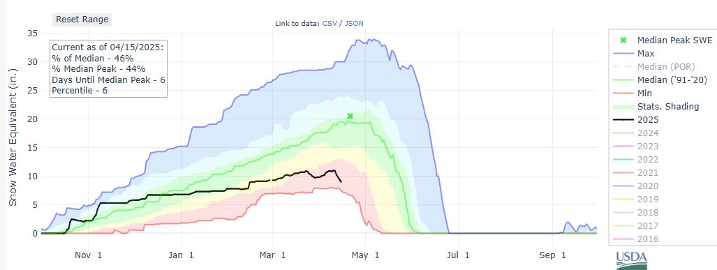
According to the SNOTEL station at South Colony, deep in the high peaks of the Sangres, the snow-water equivalent measured at the station dropped by 15 percent in just four days. Worse, the snowpack was already at low levels, and without cooler weather, the snowpack would fall to the lowest level recorded in over 30 years.
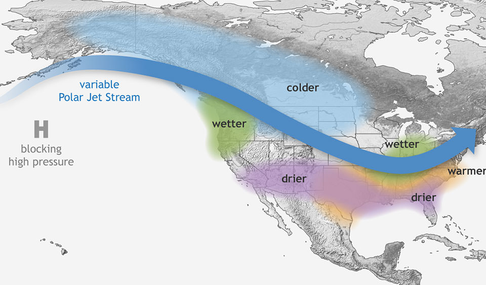
March and April are typically the snowiest months in Colorado; however, the storm systems that bring that valuable moisture have been pushed consistently to the north of the Valley due to weather patterns known as La Niña. According to the National Oceanic and Atmospheric Administration (NOAA), “La Niña means Little Girl in Spanish. La Niña is also sometimes called El Viejo, anti-El Niño, or simply “a cold event.” During La Niña events, trade winds in the Pacific Ocean at the equator are stronger than usual, pushing more warm water towards Asia. Off the west coast of the Americas, upwelling increases, bringing cold, nutrient-rich water to the surface. These cold waters in the Pacific push the jet stream northward. This tends to lead to drought in the southern U.S. and heavy rains and flooding in the Pacific Northwest and Canada. During a La Niña year, winter temperatures are warmer than normal in the South and cooler than normal in the North of the United States.”
However, the La Niña was short-lived this year, starting in December and ending at the beginning of April; the pattern ended as Pacific Ocean water temperatures had returned to normal. But what does that mean locally for the next few months?
The Tribune contacted the United States Weather Service Office in Pueblo and spoke to climate meteorologist Kyle Mozley about what to expect in the transition out of La Niña and into a regular climate pattern for North America. “Well, what we know is that typically, for the first one to three months after a La Niña cycle, we are looking to being on the dryer side of normal. During this transition period, we are looking to see if the monsoon season will be robust or not, and it is still too early to tell how the rains will be this summer.”
In Colorado, the North American Monsoon cycle ramps up at the end of June and persists from July through August. But in the meantime, the chances of moisture are a mixed bag of chance that does not favor the wet stuff. “The big thing to pay attention to is Red Flag weather warnings. If we don’t get precipitation, there is an elevated fire risk through the whole region as vegetation is already very dry, and the grass is not greening up yet.”
Yet there is a chance that this weekend, we could see some moisture as a low-pressure system moves into the Four Corners of Southwestern Colorado on Friday. Depending on how that storm tracks to the east, the Valley could see the return of much-needed snowfall. Check the Tribune website at www.wetmountaintribune.com for updates on this potential return to snow this weekend.
– Jordan Hedberg